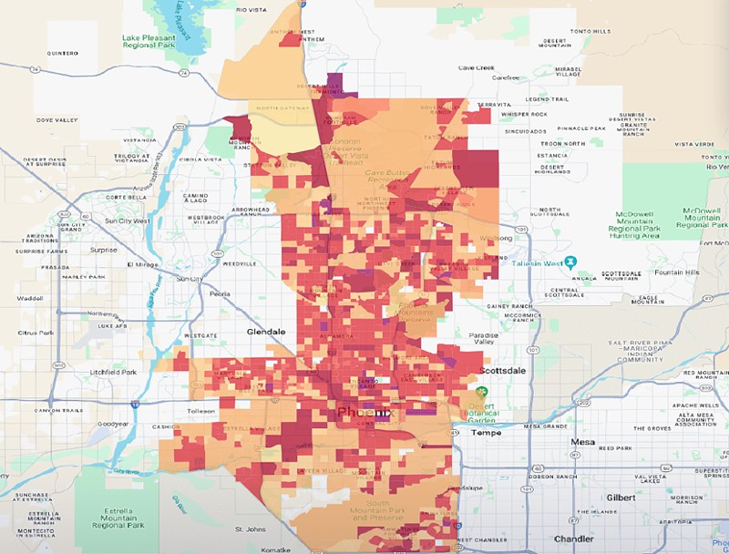
In some of the Valley of the Sun’s neighborhoods, residents face temperatures up to 10 degrees warmer than they otherwise would, according to the Urban Heat Island index released this month. Based on data from the 2020 U.S. Census, the index examines how urban infrastructure affects temperatures in 65 cities across the county.
On average, air temperatures in Phoenix are 7.4 degrees hotter than they are outside the city. That’s actually the smallest temperature increase of any city in the index, but that’s likely because Phoenix already is hot. Another hot city, Las Vegas, ranks right ahead of Phoenix.
Still, roughly 28,000 residents are experiencing temperatures 9 degrees hotter than they would in a rural setting. The effect varies by neighborhood. According to the index, temperature increases range from a 4.2-degree increase near Paradise Valley to a 10.5-degree increase near Phoenix Sky Harbor International Airport.
Notably, Paradise Valley has lots of trees, while the airport does not. The study, which examined data from Phoenix’s 2,434 census block groups, found that factors such as planting trees near streets and installing cool roofs and pavements help mitigate the heat.
Most of the Phoenix neighborhoods experiencing the greatest temperature increases are in or near downtown and midtown, with several located along a Valley Metro Rail line. The Valley’s cooler neighborhoods have more green spaces, including parks and hiking areas. They also are mostly in the north or west Phoenix suburbs.
Really, it’s hot for everyone. The National Weather Service predicts the Valley’s average temperature will be nearly 100 degrees this summer, breaking last year’s record of 97. But if you’re looking to get out of the blistering Phoenix heat this summer, we can point you in the right direction.
Here are the five hottest neighborhoods to avoid — by average temperature increase — and the five coolest to visit.

Hottest Neighborhoods
Tie-5. Executive Towers10.3 degrees hotter
Bounded by Indian School Road to the north, Central Avenue to the east, Osborn Road to the South and Third Avenue to the west. This area of midtown Phoenix contains apartment complexes, hotels, Staples and Alexi’s Grill.
Tie-5. Greenfield Acres
10.3 degrees hotter
Bounded by Cambridge Avenue to the north, Central Avenue to the east, Oak Street to the south and Third Avenue to the west. This neighborhood, comprising mostly apartment complexes and single-family homes, is just south of Phoenix Children’s Hospital.
Tie-5. Roosevelt Row, Evans Churchill
10.3 degrees hotter
Bounded by Roosevelt Street to the north, Seventh Street to the east, Fillmore Street to the South and Central Avenue to the west. This area is home to the famous Roosevelt Row’s First Friday art walk. Many restaurants, bars, coffee shops and high-rise apartments are found here.
Tie-3. Deer Valley Village
10.4 degrees hotter
Bounded by the Loop 101 to the north, 33rd Avenue to the east, Union Hills Drive to the south and 35th Avenue to the west. This mostly single-family home area has a shopping center with has a bowling alley, McDonald’s and other restaurants.
Tie-3. Homestead Terrace
10.4 degrees hotter
Bounded by Thomas Road to the north, 55th Avenue to the east, Encanto Road to the south and 59th Avenue to the west. This is a school area with Cartwright Elementary School and many single-family homes.
Tie-1. Acre City
10.5 degrees hotter
Bounded by Van Buren Street to the north, 40th Street to the east, Air Lane to the south and 32nd Street to the west. This area is close to the airport and contains Phoenix’s Park N’Swap, Gateway Community College’s Washington Campus and several trailer parks.
Tie-.1 HiaLeah, El Molino Place, Crestwood
10.5 degrees hotter
Bounded by Van Buren Street to the north, 32nd Street to the east, Air Lane to the south and 24th Street to the west. Adjacent to Acre City, this neighborhood is just north of Sky Harbor airport and contains Ballet Arizona and Phoenix Beer Co.

Paradise Valley is — you guessed it — a relative paradise.
Photographs in the Carol M. Highsmith Archive, Library of Congress, Prints and Photographs Division
Coolest Neighborhoods
Tie-5. Wigwam Creek North5.1 degrees hotter
Bounded by El Mirage Road to the east, Camelback Road to the south and Wigwam Creek Boulevard to the north and west. In a municipal no man’s land between the borders of Phoenix, Litchfield Park and Glendale, this neighborhood is a gated suburban community with a canal running through it.
Tie-5 Sunset Knoll
5.1 degrees hotter
Bounded by Cheery Lane Road to the north, 59th Avenue to the east, Thomas Road to the south and 63rd Avenue to the west. This neighborhood is a small single-family suburban area in west Phoenix.
Tie-3. Desert Sky Mall
4.9 degrees hotter
Bounded by Thomas Road to the north, 75th Avenue to the east, Encanto Road to the south and 79th Avenue to the west. This small area is defined by Desert Sky Mall, which makes up most of the neighborhood. In addition to the restaurants and shops that surround the mall, an apartment complex and Desert Sage Library are found here.
Tie-3. Harbor View Business Park
4.9 degrees hotter
Bounded by a railroad line to the north, Arizona Loop 202 to the east, Sky Harbor Boulevard to the south and State Route 143 to the west. This area, situated between several of Arizona's freeways, has lots of shaded underpasses and is just north of the Salt River on the edge of Phoenix and Tempe. The Valley Metro Light Rail Train Yard is here.
2. Pyramid Peak
4.7 degrees hotter
Bounded by Interstate 17 to the east, the Arizona Canal to the south and State Route 303 to the north. This area is a mountainous desert hiking area that includes Pyramid Peak.
1. Paradise Valley Park
4.2 degrees hotter
Bounded by Union Hills Drive to the north, 40th Street to the east, East Bell Road to the south and State Route 51 to the west. This area is home to Paradise Valley Park and Community Center, which means lots of green space. Paradise Valley High School also is in this neighborhood.