
With its central location between North Phoenix, Scottsdale and Arcadia, Piestewa Peak is not only a convenient hike to get to — it's also rewarding and breathtaking. The mountain's Summit Trail is just over a mile long to the peak, but the climb entails a steep ascent of 1,200 feet for hikers. Once there, hikers can enjoy a remarkable 360-degree view of the Phoenix metro area. And if the vertical climb on the Summit Trail isn't for you, the lesser-known Freedom Trail wraps around the base of the mountain in a 3.7-mile hike, getting you closer to the preserve's desert flora and fauna. For its accessibility, beauty and singularity, Piestewa Peak wins best overall hike.

Best Intense Hike
Echo Canyon, Camelback Mountain
One of the most popular hikes in the Valley, the Echo Canyon Trail is one of two ways to climb Camelback Mountain — and both are seriously challenging. To the top of the mountain and back to its base, the trail is about 2.4 miles and the elevation gain is about 1,423 feet. The rocky terrain and steep climb make this one of the more difficult hikes around, so don't be surprised if you have to pull yourself up from your hands and knees or rely on the handrails installed along parts of the trail. But don't be alarmed. Getting to the top of Camelback is a small triumph worth the sweat. Just make sure to bring plenty of water and be prepared for the difficulty of finding parking at the base during peak hours.
- 4925 E McDonald Dr., Phoenix, 85018 Map
Best Hike With Views
Picketpost Mountain Trail
This one's not for the faint of heart. Get ready for a 4.2-mile out-and-back trail near Superior, with cliffs that grant hikers a view of the Superstitions and beyond. Those with a fear of heights should stay home as the complicated trail corners hikers against moderate cliffs that make for a spectacular sight. Similar in difficulty to its popular cousin Flatiron, this hike calls for a bit of scrambling. But don't worry — decent shoes are enough to cling to the grippy rock texture. Hikers will know they've ended their ascent when they've reached the triumphant Picketpost mailbox filled with treasures from past hikers including letters, shooters, money and even condoms (for those who find fear an aphrodisiac). The views of nearby mountain terrain from the top of Picketpost Mountain are worth the climb. The way back down includes some butt sliding down steep rocks. Hikers who stay late can catch a gorgeous sunset view since most of the trail faces west.
Best Picnic Trail
Lone Tree via Peralta Canyon
If you're lucky, you'll beat other hikers to the best picnic spot in the Superstition Wilderness: the Lone Tree. Make sure your knees are in top shape for this one, as some of the incline can get pretty steep on this 5.4-mile out-and-back trail near Gold Canyon. The name can be attributed to the single pine tree at the end of the trail, appearing alien against the rocky, dry backdrop. This hike allows for views of Battleship Mountain, Weavers Needle, Black Mesa and Canyon Lake. And while you might be tempted to stop and enjoy a packed lunch in the shady, cool cave or the Fremont Saddle, the best spot to enjoy a picnic is at the very end. Bask under the tree's shade as you chow down or climb onto the boulders just next to it for a gorgeous view of Weavers Needle on the other side of breathtaking cliffs.
Best Sunset Hike
Lookout Mountain Loop
Hiking doesn't have to be an activity just for the weekends. The Lookout Mountain Loop, located in the heart of the city, allows you to hit the trail after work for a gorgeous sunset hike. Park at the Lookout Mountain Preserve trailhead on 16th Street, which is on the north side of the mountain. From there, you'll quickly get up onto the trail system, which offers multiple options. Turn left and join the loop that, after a moderate incline, gets you right into the wildflowers and mountain views. As you make your way around to the west side of the mountain, you'll start to see the sun setting over the distant peaks. We like to hike this loop clockwise to hike directly into the sunset. Toward the end, as you head back around to the north, the trail flattens into a scrubby brush perfect for spotting rabbits, quail and the occasional road runner. Dogs are permitted but must be on a leash. Expect to see other hikers along with solo trail runners getting in their workouts.
- 15600 N. 16th St., Phoenix, 85020 Map
- 602-262-7901
- phoenix.gov/parks/trails
Best Place to Reconnect With Our Desert Roots
McDowell Sonoran Preserve
For anyone trying to commune with nature in the Valley, you can't go wrong with Scottsdale's McDowell Sonoran Preserve. With some 31,000-plus acres, the preserve presents a smorgasbord of terrains and various difficulties for hikers, bikers and other outdoor nature enthusiasts. But it's not just about being a massive place to reconnect with the wonders of life in a dynamic desert. The McDowell Sonoran Conservancy, which helps oversee the preserve, also offers plenty of training classes and general education. Their aim is to augment your enjoyment of the preserve's offerings with a historical and social perspective as to why these places matter. That two-pronged approach is how the preserve becomes not just a place to explore but also this sustained connection to the places, values and diverse populations that have helped define this entire region. It's a living, breathing connection to this sense of community and this unwavering celebration of the natural world. Whether you hike it or bike it, the preserve is ours to explore past, present and future.
- 18333 N. Thompson Peak Parkway, Scottsdale, 85255 Map
- 480-312-7013
- www.scottsdaleaz.gov/preserve
Best Place to Take an Out-of-Town Visitor
Hole in the Rock
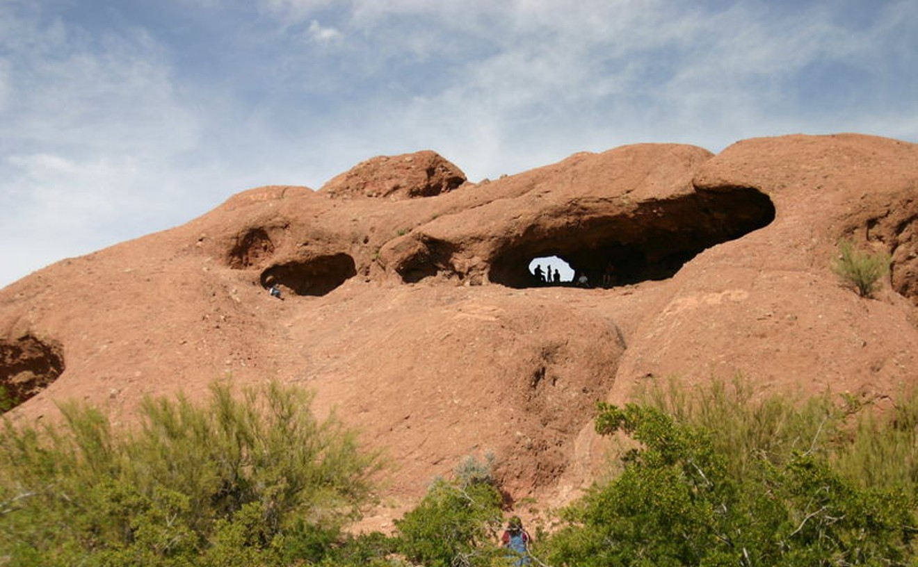
Located at Papago Park, the Hole in the Rock may be the perfect introduction to Arizona for someone visiting for the first time. The unique sandstone formation, peppered with holes formed by erosion over millions of years, is rich with history. The Hohokam may have used its holes to mark the seasons. Now, visitors use them as an irresistible Instagram backdrop. Parking is easy — there are plenty of spots near Hole in the Rock or at the nearby Phoenix Zoo — and the hike up is short at just 0.3 miles. Beginner hikers and even kids should have little problem with it, though you should wear some sturdy shoes as you climb up. Once you get there, cool yourself in the shade of the rock's titular opening and enjoy a view of the Valley that's most impressive at dusk. (Expect some company. This is a popular spot.) Your visitors can now say they've done something very Arizona, and at just a nine-minute drive from Sky Harbor, they barely had to leave the airport.
- 625 N. Galvin Parkway, Phoenix, Map
- 602-495-5458
- phoenix.gov/parks/trails/locations/papago-park
Best Place to Mountain Bike
Dirt Road Trail, South Mountain Park Preserve
New mountain bikers of any age from toddlers to retirees can (and do) ride along this forgiving trail without fear. It gradually slopes 150 feet up a 1.2-mile path before it branches off to the National Trail and gets "technical" — meaning steep, rocky and spine-jangling. But it's not boring. You'll stay entertained with hills and valleys along the climb, and once you turn around at the bench, it's a free-wheeling "wheeee" the whole way back. The scenery is another draw. Once you're a few feet into the canyon, the city drops away and you're enveloped within a serene desert oasis surrounded by all sorts of Sonoran flora and fauna. Yes, this is a busy trail used by hikers, dog walkers and equestrians, but it's also wide, so as long as you stay alert and yield to them, you're fine (although a handlebar bell is recommended to announce yourself). And if you're interested in trying a mountain e-bike, which makes the sport accessible for most fitness levels, Bike Masters of Ahwatukee offers free loaners on Friday mornings from fall through spring.
Best Walking Path
Murphy Bridle Path
It's our opinion that the stretch of Central Avenue between Northern Avenue and Bethany Home Road is one of the loveliest parts of Phoenix. Trees shade the quiet street, which is lined with luxurious and often historic homes. It's a pleasant trip up the street in a car, but even more so when we're walking on the Murphy Bridle Path. Mornings and evenings, and all through the weekend, the packed-dirt path on the east side of the street is populated with runners, couples with dogs, families and solo walkers. The path is named for William Murphy, who platted the neighborhood in 1895, and along the street, you can see signs commemorating its 100th anniversary in 1995. And yes, it was originally intended for people riding horses. But today, it remains an important piece of Phoenix history, as well as a nice place for a stroll.
Best Stairs
Victory Steps at Verrado
Hiking and bouldering are popular pastimes in the Valley, but the Victory Steps at Verrado provide a different kind of climbing challenge. Technically known as Trail 340, the stairs are really 340 railroad ties that take you above the master-planned community of Verrado in the far southwest part of metro Phoenix. Though the steps aren't too steep, you'll soon start to feel the burn in your chest and legs as you ascend. Keep going, and your reward is a lovely view of the White Tank Mountains and the surrounding areas. Then, it's time to steady your legs for the descent. There's no official address for the trail; simply get off Interstate 10 at Verrado Way, head north and look for the small parking lot near the base of the stairs. And don't forget to bring plenty of water.
Best Of Phoenix®
-
Megalopolitan Life
-
Best Political Penmanship
Austin Smith
-
Best Misogynist
Sonny Borrelli
-
Best Power Lesbian
Kris Mayes
-
Best Power Gay
Oscar De Los Santos
-
Best Mean Girl
Justine Wadsack
-
Best Republican
Stephen Richer
-
Best Democrat
Mark Kelly
-
Best Mic Drop
Paul Penzone
-
Best Day Drinkers
Republicans in the Arizona State Legislature
-
Best Anger Issues
Leezah Sun
-
Best Shot-Blocker
Katie Hobbs
-
Best Autograph Collection
Arizona Abortion Access Act Ballot Initiative
-
Best Activists
ASU Gaza Encampment
-
Best Failed Girl Boss Sellout
Kyrsten Sinema
-
Best Political Fail
Jevin Hodge
-
Best Resignation
Roger Smith
-
Best Dumpster Fire
Kari Lake
-
Best Policy Disaster
Attempted Abortion Ban
-
Best Wacko Political Race
8th Congressional District Republican Primary
-
Best Religious Nuttery
Anthony Kern
-
Best Act of Crass Favoritism
Rachel Mitchell
-
Best Act of Courage
Eva Burch
-
Best Political Parasite
Charlie Kirk
-
Best Enemy of Progress
Tom Horne
-
Best Failure to Protect and Serve
Gilbert Police Department
-
Best Show Trial
Austin Davis
-
Best Local Newsletter
Arizona Agenda
-
Best Source for LGBTQ+ News
Lookout Phoenix
-
Best TV Station for Local News
ABC15 Arizona
-
Best Instagram
Downtown Phoenix Inc.
-
Best Local TikTok
WildJoy Experiences
-
Best Local YouTube Series
Just Give Me Five
-
Best Radio Station
KRDP Community Radio (90.7 FM)
-
Best Art Museum
Phoenix Art Museum
-
Best Art Gallery
Lisa Sette Gallery
-
Best Pop-Up Art Show
'All In'
-
Best Art Festival
Canal Convergence
-
Best Outdoor Art
Oak Street Alley
-
Best Art at the Airport
'The Phoenix'
-
Best Art Along the Light Rail
'On a Journey with You'
-
Best Stuffed Animals
Trolls on Grand Avenue
-
Best First Friday Stop
Eye Lounge
-
Best Art Exhibit
'Modified Arts: A 25th Anniversary Group Invitational'
-
Best Political Exhibit
'Twin Flames: The George Floyd Uprising From Minneapolis to Phoenix'
-
Best Cultural Exhibit
'Barbie: A Cultural Icon'
-
Best Billboard
'Dictator Diaper Don Destroying Democracy'
-
Best Lowrider Painter
Efrain 'Bugs' Gonzales
-
Best Cosplayer
Rain
-
Best Breakdancer
Decoy Muñoz
-
Best Comic Artist
Albert Morales
-
Best Film Festival
Phoenix Film Festival
-
Best Hollywood Export
Emma Stone
-
Best Discount Movie Theater
Pollack Tempe Cinemas
-
Best Luxury Movie Theater
Landmark Theatres
-
Best Hope for the Phoenix Film Industry
Desert Studios Complex
-
Best Small Playhouse
The Phoenix Theatre Company
-
Best Large Playhouse
ASU Gammage
-
Best Queer Hangout
thems.
-
Best Writing Workshop
Ghost Poetry
-
Best New Gold Rush
Data Centers
-
Best One-Way Ticket to the Afterlife
Seventh Street/Seventh Avenue Suicide Lanes
-
Best Glimpse of a Robot-Controlled Future
Waymo Driverless Taxis
-
Best Guardians of Local History
Tempe History Museum
-
Best Discovery
John Milton's Handwritten Notes
-
Best Revitalization
The Abbey on Monroe
-
Best Save
Beadle House #6
-
Best Christmas Tradition
APS Electric Light Parade
-
Best Christmas House
Scary Christmas House
-
Best Halloween House
Haunted Graveyard Arizona
-
Best Fireworks Display
Fabulous Phoenix 4th at Steele Indian School Park
-
-
Fun & Games
-
Best Hike
Piestewa Peak
-
Best Intense Hike
Echo Canyon, Camelback Mountain
-
Best Hike With Views
Picketpost Mountain Trail
-
Best Picnic Trail
Lone Tree via Peralta Canyon
-
Best Sunset Hike
Lookout Mountain Loop
-
Best Place to Reconnect With Our Desert Roots
McDowell Sonoran Preserve
-
Best Place to Take an Out-of-Town Visitor
Hole in the Rock
-
Best Place to Mountain Bike
Dirt Road Trail, South Mountain Park Preserve
-
Best Walking Path
Murphy Bridle Path
-
Best Stairs
Victory Steps at Verrado
-
Best Urban Park
Margaret T. Hance Park
-
Best Slip and Fall
WM Phoenix Open
-
Best Male Athlete
Zac Gallen
-
Best Female Athlete
Brittney Griner
-
Best Little Sports Team That Could
Phoenix Rising
-
Best Use of a Singlet
Richard Figueroa
-
Best Place to Watch a Spring Training Game
Salt River Fields at Talking Stick
-
Best Secret Spot at Footprint Center
Hideaway Lounge
-
Best Disappearing Act
Arizona Coyotes
-
Best Eulogy
Todd Walsh
-
Best Sports Mascot
Sparky the Sun Devil
-
Best Scofflaws
ASU Athletics
-
Best Inability to Read the Room
Ken Kendrick
-
Best Inability to Be in the Room
Alex Meruelo
-
Place to Learn How to Putt
Putting World
-
Best Sports of the Future
Phoenix Esports
-
Best Future of Local Gaming
Velocity VR
-
Best Place to Keep a Kid Entertained
Children's Museum of Phoenix
-
Best Cat Cafe
PHX Cat Cafe
-
Best Interactive Art Activity
Spin Art Nation
-
Best Low-Key Date Night
Candlelight Concerts
-
Best Roller Rink
USA Skateland Mesa
-
Best Ice-Skating Rink
Ice Den Scottsdale
-
Best Go-Karts
Andretti Indoor Karting and Games
-
Best Waterpark
Golfland Sunsplash
-
Best Climbing Gym
Bouldering Project
-
Best Bowling Alley
Let It Roll Bowl & Entertainment Center
-
Best Upscale Indoor Fun
Lane Park
-
Best Rage Room
Breakthrough Smash Room
-
Best Indoor Gun Range
Scottsdale Gun Club
-
Best Arcade
StarFighters Arcade
-
Best Casino
Gila River Resorts & Casinos – Santan Mountain
-
Best Zoo
Phoenix Zoo
-
Best Aquarium
Sea Life Arizona
-
Best Rides
Castles N' Coasters
-
Best Pool Hall
JJ's Bar and Billiard
-
Best Public Pool
McDowell Mountain Ranch Aquatic & Fitness Center
-
Best Public Pickleball Courts
Pecos Park
-
Best Stairway to Heaven
Estrella Star Tower
-
Best Staycation Spot
Arizona Biltmore
-
Best Excuse to Take Your Pants Off in Public
Phoenix No Pants Light Rail Ride
-
Best Place to See Classic Cars
Martin Auto Museum
-
Best Drift Car Show
Slangin' Smoke
-
Best Lowrider Show
Guadalupe Car Show
-
-
Goods & Services
-
Best Store Full of Surprises
Hawk Salvage
-
Best Bodega
Monsoon Market
-
Best Place to Shop If You're Missin' the Mitten
Michigan Marketplace
-
Best Tiny Things
Auntie Em's Miniatures
-
Best Record Store
Stinkweeds
-
Best New Record Store
Nile Records
-
Best Bookstore
Changing Hands Bookstore
-
Best Used Bookstore
Bookmans Entertainment Exchange
-
Best Book Sale
VNSA Used Book Sale
-
Best Pop-Up Market
Melrose Vintage Market
-
Best Boutique
Bunky Boutique
-
Best Place to Shop for Gifts
Frances
-
Best Upscale Party Supplies
UrbAna
-
Best Future of Fashion
Fair Trade With Redemption Market
-
Best Vintage Clothing
Antique Sugar
-
Best Men's Clothing
Cave + Post Trading Co.
-
Best Women's Clothing
Local Nomad
-
Best Costume Shop
JLS Costumes
-
Best Vintage T-Shirts
Wang's Vintage
-
Best Rave Gear
Rave Circus
-
Best High-End Sneaker Shop
Archive
-
Best Running Shop
Road Runner Sports
-
Best Place to Dress Like a Tennis Player
Arcadia Tennis Shop
-
Best Outdoors Store
Just Roughin' It Adventure Co.
-
Best Fireworks Store
San Tan Fireworks
-
Best Adult Shop
Groove
-
Best Smoke Shop
HQ Vape & Smoke
-
Best Place to Find Your Way
Wide World Maps & More!
-
Best Crystals
Everything Just Rocks
-
Best New Age Store
Fantasia Crystals
-
Best Baking Supplies
ABC Cake Decorating Supplies
-
Best Fabric Store
SAS Fabrics
-
Best Antiques Mall
The Brass Armadillo
-
Best Antique Store
Modern Manor
-
Best Midcentury Modern Furniture
Red Modern Furniture
-
Best Local Art
Practical Art
-
Best Shop for Arizona Merch
The Merchantile
-
Best Indigenous-Made Goods
Native Art Market
-
Best Bath and Body Goods
Strawberry Hedgehog
-
Best Art Supplies
Jerry's Artarama
-
Best Religious Supplies
Autom
-
Best Creepy Stuff
Curious Nature
-
Place for Vintage Pop Culture
3G Vintage
-
Best Store for Your Inner Dino Nerd
Tyrannostorus
-
Best LEGO Store
Arizona Brick Co.
-
Best RC Lowrider Cars
Redcat Racing
-
Best Place for Horror Buffs
Terror Trader
-
Best Hip-Hop Shop
Trill
-
Best Skate Shop
Cowtown Skateboards
-
Best Store for Wrestling Fans
The Wrestling Guy Store PHX
-
Best Comic Book Shop
Ash Avenue Comics
-
Best Game Store
Funkatronic Rex
-
Best Video Game Store
The Gaming Zone
-
Best Massive Bouquets
La Ocasion Flower Shop
-
Best Place to Get Coffee and Flowers
Stemistry
-
Best Plant Nursery
Berridge Nurseries
-
Best Plant Shop
Pueblo
-
Best Place to Pamper Your Pooch
Puff & Fluff Grooming
-
Best Museum Gift Shop
Musical Instrument Museum
-
Best Mall
Scottsdale Fashion Square
-
-
La Vida
-
Best Farewell
Barrio Café
-
Best Return
Kristen Martinez
-
Best Mexican Restaurant
Bacanora
-
Best Late-Night Mexican Food
Baja Roots
-
Best Mexican Food Truck
Comiendo Con Memo
-
Best Pueblan Food
El Rincon Poblano Mexican Grill
-
Best Oaxacan Food
Oaxaca Restaurant
-
Best Chihuahuan Food
Testal Mexican Kitchen
-
Best Mexican Diner
El Horseshoe Restaurant
-
Best Vegan Mexican Food
Tacos Veganos
-
Best Upscale Mexican Restaurant
Santo
-
Best Tacos
Juanderful Tacos
-
Best Gorditas
Tacos Chiwas
-
Best Burritos
Rito's Mexican Food
-
Best Breakfast Burrito
El Norteño
-
Best Barbacoa
La Mejor Comida Mexicana
-
Best Carne Asada
Ta'Carbon Mexican Grill
-
Best Carne Asada Fries
Taco Viva
-
Best Al Pastor
Taqueria El Trompo
-
Best Carnitas
Los Compadres Carniceria
-
Best Tortas
Tortas el Rey
-
Best Birria
Hola Cabrito
-
Best Chimichangas
Rosita's Place
-
Best Sonoran Hot Dog
Emilio's Tacos & Hotdogs
-
Best Mole
Las 15 Salsas
-
Best Guacamole
Call Her Martina
-
Best Pozole
Alebrijes Cafe & Grill
-
Best Mexican Sushi
El Tataki Sushi Fusion
-
Best Mariscos
Mariscos Playa Hermosa
-
Best Mexican Bakery
La Purisima Bakery
-
Best Churros
Dulce Churro Cafe
-
Best Aguas Frescas
Tortas Manantial
-
Best Tequila Bar
Barcoa Agaveria
-
Best Import from Mexico
Buqui Bichi Brewing
-
Best Mexican Coffee Shop
Deseo A Coffee Shack
-
Best Margaritas
CRUjiente Tacos
-
Best Cheap Margaritas
Mi Patio
-
Best Mexican Grocery Store
Los Altos Ranch Market
-
Best Marketplace
Mercado De Los Cielos (inside Desert Sky Mall)
-
Best Bilingual Bookstore
Palabras Bilingual Bookstore
-
Best Spanish-Language Radio Station
La Onda (KNUV 1190 AM)
-
Best Place to Buy a Quinceañera Dress
Quinceañera Divaine Boutique
-
Best Mexican Imports Store
Mexican Arts Imports
-
Best Dia de Los Muertos Goods
Arizona Latino Arts and Cultural Center
-
Best Place to See Latino Art
Xico Inc.
-
Best Place to See Lucha Libre
Por Promotions
-
Best Latin Nightclub
El Capri
-
Best Spanish-Language Rapper
El Poeta
-
-
Food & Drink
-
Best Handoff
Kevin Binkley to Stephen Jones
-
Best Community Food Resource
Borderlands Produce Rescue
-
Best Flagstaff Import
The Toasted Owl Cafe
-
Best Tucson Import
Barrio Bread
-
Best One-Two Punch
Chef Angelo Sosa
-
Best Restaurant
Valentine
-
Best New Restaurant
Pretty Penny
-
Best Chef
Claudio Urciuoli
-
Best Pastry Chef
Crystal Kass
-
Best Place to Take a Foodie
Uchi
-
Best Restaurant to Take a Geek
Wally Burger
-
Best Place to Treat Your Mom
Lon's at The Hermosa
-
Best Place to Eat Before a Downtown Event
Harumi Sushi
-
Best Place to Eat Before a Glendale Event
Los Arbolitos de Cajeme
-
Best Place to Find a Pop-Up
Sauvage Wine Bar and Shop
-
Best Cook-It-Yourself Restaurant
Mr. Baan's Bar & Mookata
-
Best Late-Night Eats
Cornish Pasty Co.
-
Best Underground Restaurant
Rough Rider
-
Best Authentic Arizona Restaurant
Fry Bread House
-
Best Hotel Restaurant
Chilte
-
Best Weekly Specials
Chula Seafood
-
Best Fast Food
Oscar's Pier 83
-
Best Happy Hour
Buck & Rider
-
Best Breakfast
Fàme Caffe
-
Best Brunch
SugarJam The Southern Kitchen
-
Best Restaurant Patio
Cibo
-
Best Secret Patio
The Churchill
-
Best Restaurant Views
Christopher's at Wrigley Mansion
-
Best Takeout
Kabob Grill N' Go
-
Best Bar Food
Bar Cena
-
Best Date Night Spot
Progress
-
Best Steakhouse
The Stockyards
-
Best Restaurant You Can Ride Your Horse To
T-Bone Steak House
-
Best Haunted Restaurant
The Old Spaghetti Factory
-
Best Classic Diner
Joe's Diner
-
Best Trendy Diner
Sidewinder
-
Best Southern Food
CC's on Central
-
Best New Mexico Cuisine
Richardson's
-
Best Hawaiian Restaurant
Hapa Food Co.
-
Best British Pub
George & Dragon
-
Best Irish Pub
Seamus McCaffrey's Irish Pub
-
Best Italian Restaurant
Andreoli Italian Grocer
-
Best French Restaurant
Sottise
-
Best Caribbean Restaurant
Cool Vybz Jamaican Restaurant
-
Best Vietnamese Restaurant
Broken Rice
-
Best Korean Restaurant
Ban Chan Korean Cuisine
-
Best Thai Restaurant
Lom Wong
-
Best Korean Barbecue
Sizzle Korean BBQ
-
Best Japanese Restaurant
ShinBay
-
Best Traditional Chinese Restaurant
Old Town Taste
-
Best Canto-American Chinese Food
George Yang's Chinese Cuisine
-
Best Upscale Indian Restaurant
Feringhee Modern Indian Cuisine
-
Best Middle Eastern Restaurant
Golden Restaurant & Bakery
-
Best Neighborhood Indian Spot
The Dhaba
-
Best Halal Restaurant
City of Spice
-
Best North African Restaurant
Alzohour Restaurant
-
Best East African Restaurant
Kare Ethiopian Restaurant
-
Best West African Restaurant
West African Cuisine
-
Best Eastern European Restaurant
All Pierogi Kitchen
-
Best Jewish Deli
Goldman's Deli
-
Best Vegan Restaurant
Uniq Burger
-
Best Farmers' Market
Uptown Farmers Market
-
Best Asian Grocery Store
H Mart
-
Best Japanese Market
New Tokyo Food Market
-
Best Italian Deli
Romanelli's Italian Deli
-
Best Eastern European Market
A to Z Polish Market
-
Best Butcher
Arcadia Meat Market
-
Best Fish Shop
Nelson's Meat + Fish
-
Best Sandos
Fatboy Sandos
-
Best Hamburgers
Stoop Kid
-
Best Hot Dogs
Ted's Hot Dogs
-
Best Chicken Wings
Valley Wings
-
Best Chopped Cheese
Meat the Cheese
-
Best Barbecue
Little Miss BBQ
-
Best Pizza
Mimi Forno Italiano
-
Best Salads
Perfect Pear Bistro
-
Best Sushi
Shimogamo
-
Best Ramen
Origami Ramen Bar
-
Best Dim Sum
Great Wall
-
Best Dumplings
Happy Bao's
-
Best British Bakery
The Great Gadsby
-
Best Pastries
JL Patisserie
-
Best Bread
Nice Buns
-
Best Bagels
The Bagel Man
-
Best Cookies
Urban Cookies Bakeshop
-
Best Breakfast Sandwich
Berdena's
-
Best Italian Ice
Joe's Italian Ice
-
Best Doughnuts
Dutch Donut Factory
-
Best Ice Cream
Novel Ice Cream
-
Best Gelato
Cool Gelato Italiano
-
Best Bonbons
Chocofin Chocolatier
-
Best Coffeehouse
Dialog
-
Best New Coffeehouse
Bang Bang Coffee
-
Best Coffee Roasters
Peixoto Coffee Roasters
-
Best Matcha
Driftwood Coffee Co.
-
Best Brewery
Wren House Brewing Co.
-
Best New Brewery
Catalyst Crafted Ales
-
Best Bike-Friendly Brewery
O.H.S.O. on Central
-
Best Food at a Brewery
Peoria Artisan Brewery
-
Best Place to Pour Your Own Beer
Tap That Downtown
-
Best Arizona Wine Selection
FnB
-
Best Wine on Tap
GenuWine Arizona
-
Best Place to Take a Wine Geek
Hidden Track Bottle Shop & Wine Bar
-
Best Arizona White Wine
Callaghan Vineyards 2021 Love Muffin White
-
Best Arizona Red Wine
Chateau Tumbleweed 2021 Le Blend
-
Best Liquor Store
Trevor's Liquor
-
Best AZ-Born Nonalcoholic Beverage
Big Marble Organics
-
-
Nightlife
-
Best Really Big Honor
The Rebel Lounge
-
Best Birthday Party
Sessanta
-
Best Show of Support
The Rhythm Room's Parking Lot Fundraiser
-
Best Memorabilia
Danny Zelisko
-
Best Anniversary
Circus Mexicus
-
Best Fakeout
Mick Jagger
-
Best Concert for a Cause
Alice Cooper's Christmas Pudding
-
Best Bar
Platform 18 at Century Grand
-
Best New Bar
Quartz
-
Best Cocktail Creator
Jesse Knox
-
Best Speakeasy
Pigtails
-
Best New Speakeasy
Tell Your Friends
-
Best Neighborhood Bar
Casey Moore's Oyster House
-
Best Dive Bar
The Bikini Lounge
-
Best Sports Bar
Santisi Brothers
-
Best Tiki Bar
UnderTow
-
Best Game Bar
Taproom-120
-
Best Hidden Bar
Stardust Pinbar
-
Best Rooftop Bar
Skysill Rooftop Lounge
-
Best Bar for Bachelor Parties
Maya
-
Best Bar for Bachelorette Parties
Wine Girl
-
Best Non-Alcoholic Drink Options
Maple House
-
Best Place to Take a Cocktail Geek
Fuck You Pay Me
-
Best New Nightclub
Thundercat Lounge
-
Best Nightclub
Cake Nightclub
-
Best Open Mic Night
Tempe Center for the Arts
-
Best Blues Bar
Westside Blues, Jazz & More
-
Best Rock Bar
Chopper John's
-
Best Place to See a Punk Show
Yucca Tap Room
-
Best Place to See a Metal Show
The 44 Sports Grill & Nightlife
-
Best Reggae Venue
Marquee Theatre
-
Best Country Bar
The Dirty Drummer
-
Best EDM Venue
Walter Where?House
-
Best After-Hours Dance Spot
Karamba Nightclub
-
Best Jukebox
Gracie's Tax Bar
-
Best Large Music Venue
Talking Stick Resort Amphitheatre
-
Best Midsize Music Venue
The Van Buren
-
Best Small Music Venue
Crescent Ballroom
-
Best Strip Club
Jaguars Club
-
Best Lesbian Bar
Boycott Bar
-
Best Gay Bar
Charlie's Phoenix
-
Best New Gay Bar That's Really Not
The Royale
-
Best Drag Shows
Kobalt Bar
-
Best Drag Bingo
The Hot Chick
-
Best Gambling with Gay Men
Nu-Towne Saloon
-
Best Drag Queen in Denim
Evita Peroxide
-
Best Burlesque
Spellbound Burlesque
-
Best Hip-Hop Event
AZ Hip Hop Fest
-
Best Hip-Hop Artist
The Lord's
-
Best Band
Snailmate
-
Best Album
Chrome Rhino
-
Best DJ
Pete "SuperMix" Salaz
-
-
Cannabis
-
Best Local Pot Icon
HotRock SupaJoint
-
Best Artist Collab
Timeless Vapes x Nyla Lee
-
Best Cannabis Trend
Unionization
-
Best Cannabis Lounge
Exhale Society
-
Best Place to Get a Medical Marijuana Card
The Marijuana Doctor
-
Best Medical Marijuana Delivery Service
Supurb
-
Best Source of Cannabis Industry News
Cannabis Cactus
-
Best Cannabis DJ
DJ Benz
-
Best Cannabis Athlete
Marcus McGhee
-
Best Cannabis Brand Ambassador
Molly O'Malia
-
Best Way to Paint and Puff
Pretty Dope Paintings
-
Best Dispensary
Curaleaf
-
Best Home Cultivation Store
GrowersHouse
-
Best First-Time Patient Specials
Trulieve
-
Best Budtenders
Arizona Organix
-
Best Dispensary Atmosphere
Cannabist Tempe
-
Best Head Shop
Bud's Glass Joint/Bud's on Grand
-
Best Cannabis Suppositories
THC Living
-
Best Cannabis Event
Marijuana Industry Trade Association
-
Best Cannabis Concert
Arizona Cannabis Awards Music Festival
-
Best Cannabis-Infused Food
The Mint Cafe
-
Best Marijuana Education and Resources
Jars Cannabis
-
Best Cheap Prerolls
The Flower Shop
-
Best House Brand Flower
Sunday Goods
-
Best Gummies
Pure
-
Best Cannabis Baked Goods
Amy and Al's
-
Best Indica Flower
Blue Blitz
-
Best Hybrid Flower
Permanent Marker
-
Best Sativa Flower
Jenny Kush
-
Best Cartridge
Grape Durbz AIO Live Resin Vape (1000mg)
-
Best Shatter
Mohave Gold Shatter High Octane X Gelato
-
Best Wax
Lucid Blue Live Resin Sugar
-
Best Rosin
Chocolate and Cream LHR
-
-
Readers' Choice
-
Best of Phoenix 2024 Readers' Choice
-
Best Country Bar
Rusty Spur Saloon
-
Best Dive Bar
Gracie's Tax Bar
-
Best Family-Friendly Fun
Phoenix Zoo
-
Best Festival
Buds-A-Palooza
-
Best Large Music Venue
The Van Buren
-
Best Museum
Musical Instrument Museum
-
Best Performing Arts Center
Mesa Arts Center
-
Best Pool Party
Summer Oasis Pool Party at Gila River Resorts & Casinos - Wild Horse Pass
-
Best Rock Club
Yucca Tap Room
-
Best Small Music Venue
Crescent Ballroom
-
Best Sports Bar
Zipps Sports Grill
-
Best Strip Club
Alaskan Bush Co.
-
Best "OG" Restaurant
Durant's
-
Best 24 Hours Restaurant
Filiberto's Mexican Food
-
Best Antojitos (Little Cravings)
Alebrije Neveria
-
Best Asian Restaurant
Glai Baan
-
Best Bagels
Bagel Gourmet
-
Best Barbecue
Little Miss BBQ
-
Best Birria
Birrieria Obregon
-
Best Breakfast
Ranch House Grille
-
Best Brewery
Four Peaks Brewing Company
-
Best Brunch
Fàme Caffe
-
Best Burger
Aftermath
-
Best Burrito
PHX Burrito House
-
Best Chilaquiles
Otro Cafe
-
Best Cocktails
Little Rituals
-
Best Coffeehouse
Valley Coffee Company
-
Best Diner
Welcome Diner
-
Best Dog-Friendly Dining
O.H.S.O. Eatery & nano-Brewery
-
Best Fried Chicken
Mrs. Chicken
-
Best Happy Hour
HULA'S Modern Tiki
-
Best Hot Dogs
Short Leash Hotdogs
-
Best Ice Cream Shop
Novel Ice Cream
-
Best Industry Night
Gracie's Tax Bar
-
Best Late Night Dining
Cornish Pasty Co.
-
Best Margarita
Valle Luna
-
Best Mariscos
Mariscos Playa Hermosa
-
Best Mexican Sushi
Sushi Sonora
-
Best New Restaurant
Born & Bred
-
Best Patio Dining
Chelsea's Kitchen
-
Best Pizza
Spinato's
-
Best Ramen
Jinya Ramen Bar
-
Best Restaurant for Large Parties
Ocotillo
-
Best Restaurants with Activities
The Yard
-
Best Sandwiches
La Casa De La Poblanita
-
Best Sonoran Hot Dogs
El Caprichoso
-
Best Seafood
Buck & Rider
-
Best South American Restaurant
El Chullo Peruvian Restaurant & Bar
-
Best Steakhouse
Steak 44
-
Best Sushi
Harumi Sushi & Sake
-
Best Tacos
Taco Boy's
-
Best Wine Bar
Postino
-
Best Vegan Restaurant
UNIQ Burger
-
Best Wings
Long Wong's 28th St
-
Best Adult Store
Fascinations
-
Best Attorney
Lerner and Rowe Injury Attorneys
-
Best Bike Store
Landis Cyclery
-
Best Bookstore
Changing Hands Bookstore
-
Best Boutique
Local Nomad
-
Best Camera Shop
Tempe Camera
-
Best Comic Book or Collectibles Store
The Toy Box
-
Best Doggy Day Care
Dogtopia
-
Best Framing Shop
Framin' Works
-
Best Mexican Import Store
Victoria Imports
-
Best Record Store
Stinkweeds Record Store
-
Best Plant Store
Plant Stand of Arizona
-
Best Running Store
Runner's Den
-
Best Shopping Center
Scottsdale Fashion Square
-
Best Sneaker Shop
Manor
-
Best Vintage Clothing Boutique
Luxie Vintage
-
Best Wellness Center
Phoenix Community Acupuncture
-
Best Casino
Gila River Resorts & Casinos - Wild Horse Pass
-
Best Entertainment Center
Dynamic Escape Rooms
-
Best Fitness Studio
Groundwrk Phoenix
-
Best Golf Course
Arizona Biltmore Golf Club
-
Best Hiking Trail
Echo Canyon at Camelback Mountain
-
Best Indoor Golf
Stinger's Golf Club
-
Best Outdoor Experience
Desert Botanical Garden
-
Best Pickleball Venue
Pickleball Backyard
-
Best Place to See a Sporting Event
Chase Field
-
Best Staycation Spot
Sanctuary Camelback Mountain
-
Best Cannabis Product for Energy or Focus
Select Go Go Guava Fruit Stiq
-
Best Cannabis Product for Sleeping
WYLD THC CBD CBN Sleep Gummy
-
Best Cannabis Vape
Canamo
-
Best Concentrates Brand
Grow Sciences
-
Best Dispensary for Deals
JARS Cannabis
-
Best Dispensary for Selection
JARS Cannabis
-
Best Dispensary for Service
Ponderosa Dispensary
-
Best Edibles Brand
OGeez!
-
Best Flower Brand
Sonoran Roots
-
Best Head Shop
Sky High Smoke Shop
-
Best Independent Dispensary
Sunday Goods
-
Best Infused Preroll
Jeeter
-
Best Preroll
Charlie's Premium Flower Cones
-
Best Of
-
Megalopolitan Life
-
Best Political Penmanship
Austin Smith
-
Best Misogynist
Sonny Borrelli
-
Best Power Lesbian
Kris Mayes
-
Best Power Gay
Oscar De Los Santos
-
Best Mean Girl
Justine Wadsack
-
Best Republican
Stephen Richer
-
Best Democrat
Mark Kelly
-
Best Mic Drop
Paul Penzone
-
Best Day Drinkers
Republicans in the Arizona State Legislature
-
Best Anger Issues
Leezah Sun
-
Best Shot-Blocker
Katie Hobbs
-
Best Autograph Collection
Arizona Abortion Access Act Ballot Initiative
-
Best Activists
ASU Gaza Encampment
-
Best Failed Girl Boss Sellout
Kyrsten Sinema
-
Best Political Fail
Jevin Hodge
-
Best Resignation
Roger Smith
-
Best Dumpster Fire
Kari Lake
-
Best Policy Disaster
Attempted Abortion Ban
-
Best Wacko Political Race
8th Congressional District Republican Primary
-
Best Religious Nuttery
Anthony Kern
-
Best Act of Crass Favoritism
Rachel Mitchell
-
Best Act of Courage
Eva Burch
-
Best Political Parasite
Charlie Kirk
-
Best Enemy of Progress
Tom Horne
-
Best Failure to Protect and Serve
Gilbert Police Department
-
Best Show Trial
Austin Davis
-
Best Local Newsletter
Arizona Agenda
-
Best Source for LGBTQ+ News
Lookout Phoenix
-
Best TV Station for Local News
ABC15 Arizona
-
Best Instagram
Downtown Phoenix Inc.
-
Best Local TikTok
WildJoy Experiences
-
Best Local YouTube Series
Just Give Me Five
-
Best Radio Station
KRDP Community Radio (90.7 FM)
-
Best Art Museum
Phoenix Art Museum
-
Best Art Gallery
Lisa Sette Gallery
-
Best Pop-Up Art Show
'All In'
-
Best Art Festival
Canal Convergence
-
Best Outdoor Art
Oak Street Alley
-
Best Art at the Airport
'The Phoenix'
-
Best Art Along the Light Rail
'On a Journey with You'
-
Best Stuffed Animals
Trolls on Grand Avenue
-
Best First Friday Stop
Eye Lounge
-
Best Art Exhibit
'Modified Arts: A 25th Anniversary Group Invitational'
-
Best Political Exhibit
'Twin Flames: The George Floyd Uprising From Minneapolis to Phoenix'
-
Best Cultural Exhibit
'Barbie: A Cultural Icon'
-
Best Billboard
'Dictator Diaper Don Destroying Democracy'
-
Best Lowrider Painter
Efrain 'Bugs' Gonzales
-
Best Cosplayer
Rain
-
Best Breakdancer
Decoy Muñoz
-
Best Comic Artist
Albert Morales
-
Best Film Festival
Phoenix Film Festival
-
Best Hollywood Export
Emma Stone
-
Best Discount Movie Theater
Pollack Tempe Cinemas
-
Best Luxury Movie Theater
Landmark Theatres
-
Best Hope for the Phoenix Film Industry
Desert Studios Complex
-
Best Small Playhouse
The Phoenix Theatre Company
-
Best Large Playhouse
ASU Gammage
-
Best Queer Hangout
thems.
-
Best Writing Workshop
Ghost Poetry
-
Best New Gold Rush
Data Centers
-
Best One-Way Ticket to the Afterlife
Seventh Street/Seventh Avenue Suicide Lanes
-
Best Glimpse of a Robot-Controlled Future
Waymo Driverless Taxis
-
Best Guardians of Local History
Tempe History Museum
-
Best Discovery
John Milton's Handwritten Notes
-
Best Revitalization
The Abbey on Monroe
-
Best Save
Beadle House #6
-
Best Christmas Tradition
APS Electric Light Parade
-
Best Christmas House
Scary Christmas House
-
Best Halloween House
Haunted Graveyard Arizona
-
Best Fireworks Display
Fabulous Phoenix 4th at Steele Indian School Park
-
-
Fun & Games
-
Best Hike
Piestewa Peak
-
Best Intense Hike
Echo Canyon, Camelback Mountain
-
Best Hike With Views
Picketpost Mountain Trail
-
Best Picnic Trail
Lone Tree via Peralta Canyon
-
Best Sunset Hike
Lookout Mountain Loop
-
Best Place to Reconnect With Our Desert Roots
McDowell Sonoran Preserve
-
Best Place to Take an Out-of-Town Visitor
Hole in the Rock
-
Best Place to Mountain Bike
Dirt Road Trail, South Mountain Park Preserve
-
Best Walking Path
Murphy Bridle Path
-
Best Stairs
Victory Steps at Verrado
-
Best Urban Park
Margaret T. Hance Park
-
Best Slip and Fall
WM Phoenix Open
-
Best Male Athlete
Zac Gallen
-
Best Female Athlete
Brittney Griner
-
Best Little Sports Team That Could
Phoenix Rising
-
Best Use of a Singlet
Richard Figueroa
-
Best Place to Watch a Spring Training Game
Salt River Fields at Talking Stick
-
Best Secret Spot at Footprint Center
Hideaway Lounge
-
Best Disappearing Act
Arizona Coyotes
-
Best Eulogy
Todd Walsh
-
Best Sports Mascot
Sparky the Sun Devil
-
Best Scofflaws
ASU Athletics
-
Best Inability to Read the Room
Ken Kendrick
-
Best Inability to Be in the Room
Alex Meruelo
-
Place to Learn How to Putt
Putting World
-
Best Sports of the Future
Phoenix Esports
-
Best Future of Local Gaming
Velocity VR
-
Best Place to Keep a Kid Entertained
Children's Museum of Phoenix
-
Best Cat Cafe
PHX Cat Cafe
-
Best Interactive Art Activity
Spin Art Nation
-
Best Low-Key Date Night
Candlelight Concerts
-
Best Roller Rink
USA Skateland Mesa
-
Best Ice-Skating Rink
Ice Den Scottsdale
-
Best Go-Karts
Andretti Indoor Karting and Games
-
Best Waterpark
Golfland Sunsplash
-
Best Climbing Gym
Bouldering Project
-
Best Bowling Alley
Let It Roll Bowl & Entertainment Center
-
Best Upscale Indoor Fun
Lane Park
-
Best Rage Room
Breakthrough Smash Room
-
Best Indoor Gun Range
Scottsdale Gun Club
-
Best Arcade
StarFighters Arcade
-
Best Casino
Gila River Resorts & Casinos – Santan Mountain
-
Best Zoo
Phoenix Zoo
-
Best Aquarium
Sea Life Arizona
-
Best Rides
Castles N' Coasters
-
Best Pool Hall
JJ's Bar and Billiard
-
Best Public Pool
McDowell Mountain Ranch Aquatic & Fitness Center
-
Best Public Pickleball Courts
Pecos Park
-
Best Stairway to Heaven
Estrella Star Tower
-
Best Staycation Spot
Arizona Biltmore
-
Best Excuse to Take Your Pants Off in Public
Phoenix No Pants Light Rail Ride
-
Best Place to See Classic Cars
Martin Auto Museum
-
Best Drift Car Show
Slangin' Smoke
-
Best Lowrider Show
Guadalupe Car Show
-
-
Goods & Services
-
Best Store Full of Surprises
Hawk Salvage
-
Best Bodega
Monsoon Market
-
Best Place to Shop If You're Missin' the Mitten
Michigan Marketplace
-
Best Tiny Things
Auntie Em's Miniatures
-
Best Record Store
Stinkweeds
-
Best New Record Store
Nile Records
-
Best Bookstore
Changing Hands Bookstore
-
Best Used Bookstore
Bookmans Entertainment Exchange
-
Best Book Sale
VNSA Used Book Sale
-
Best Pop-Up Market
Melrose Vintage Market
-
Best Boutique
Bunky Boutique
-
Best Place to Shop for Gifts
Frances
-
Best Upscale Party Supplies
UrbAna
-
Best Future of Fashion
Fair Trade With Redemption Market
-
Best Vintage Clothing
Antique Sugar
-
Best Men's Clothing
Cave + Post Trading Co.
-
Best Women's Clothing
Local Nomad
-
Best Costume Shop
JLS Costumes
-
Best Vintage T-Shirts
Wang's Vintage
-
Best Rave Gear
Rave Circus
-
Best High-End Sneaker Shop
Archive
-
Best Running Shop
Road Runner Sports
-
Best Place to Dress Like a Tennis Player
Arcadia Tennis Shop
-
Best Outdoors Store
Just Roughin' It Adventure Co.
-
Best Fireworks Store
San Tan Fireworks
-
Best Adult Shop
Groove
-
Best Smoke Shop
HQ Vape & Smoke
-
Best Place to Find Your Way
Wide World Maps & More!
-
Best Crystals
Everything Just Rocks
-
Best New Age Store
Fantasia Crystals
-
Best Baking Supplies
ABC Cake Decorating Supplies
-
Best Fabric Store
SAS Fabrics
-
Best Antiques Mall
The Brass Armadillo
-
Best Antique Store
Modern Manor
-
Best Midcentury Modern Furniture
Red Modern Furniture
-
Best Local Art
Practical Art
-
Best Shop for Arizona Merch
The Merchantile
-
Best Indigenous-Made Goods
Native Art Market
-
Best Bath and Body Goods
Strawberry Hedgehog
-
Best Art Supplies
Jerry's Artarama
-
Best Religious Supplies
Autom
-
Best Creepy Stuff
Curious Nature
-
Place for Vintage Pop Culture
3G Vintage
-
Best Store for Your Inner Dino Nerd
Tyrannostorus
-
Best LEGO Store
Arizona Brick Co.
-
Best RC Lowrider Cars
Redcat Racing
-
Best Place for Horror Buffs
Terror Trader
-
Best Hip-Hop Shop
Trill
-
Best Skate Shop
Cowtown Skateboards
-
Best Store for Wrestling Fans
The Wrestling Guy Store PHX
-
Best Comic Book Shop
Ash Avenue Comics
-
Best Game Store
Funkatronic Rex
-
Best Video Game Store
The Gaming Zone
-
Best Massive Bouquets
La Ocasion Flower Shop
-
Best Place to Get Coffee and Flowers
Stemistry
-
Best Plant Nursery
Berridge Nurseries
-
Best Plant Shop
Pueblo
-
Best Place to Pamper Your Pooch
Puff & Fluff Grooming
-
Best Museum Gift Shop
Musical Instrument Museum
-
Best Mall
Scottsdale Fashion Square
-
-
La Vida
-
Best Farewell
Barrio Café
-
Best Return
Kristen Martinez
-
Best Mexican Restaurant
Bacanora
-
Best Late-Night Mexican Food
Baja Roots
-
Best Mexican Food Truck
Comiendo Con Memo
-
Best Pueblan Food
El Rincon Poblano Mexican Grill
-
Best Oaxacan Food
Oaxaca Restaurant
-
Best Chihuahuan Food
Testal Mexican Kitchen
-
Best Mexican Diner
El Horseshoe Restaurant
-
Best Vegan Mexican Food
Tacos Veganos
-
Best Upscale Mexican Restaurant
Santo
-
Best Tacos
Juanderful Tacos
-
Best Gorditas
Tacos Chiwas
-
Best Burritos
Rito's Mexican Food
-
Best Breakfast Burrito
El Norteño
-
Best Barbacoa
La Mejor Comida Mexicana
-
Best Carne Asada
Ta'Carbon Mexican Grill
-
Best Carne Asada Fries
Taco Viva
-
Best Al Pastor
Taqueria El Trompo
-
Best Carnitas
Los Compadres Carniceria
-
Best Tortas
Tortas el Rey
-
Best Birria
Hola Cabrito
-
Best Chimichangas
Rosita's Place
-
Best Sonoran Hot Dog
Emilio's Tacos & Hotdogs
-
Best Mole
Las 15 Salsas
-
Best Guacamole
Call Her Martina
-
Best Pozole
Alebrijes Cafe & Grill
-
Best Mexican Sushi
El Tataki Sushi Fusion
-
Best Mariscos
Mariscos Playa Hermosa
-
Best Mexican Bakery
La Purisima Bakery
-
Best Churros
Dulce Churro Cafe
-
Best Aguas Frescas
Tortas Manantial
-
Best Tequila Bar
Barcoa Agaveria
-
Best Import from Mexico
Buqui Bichi Brewing
-
Best Mexican Coffee Shop
Deseo A Coffee Shack
-
Best Margaritas
CRUjiente Tacos
-
Best Cheap Margaritas
Mi Patio
-
Best Mexican Grocery Store
Los Altos Ranch Market
-
Best Marketplace
Mercado De Los Cielos (inside Desert Sky Mall)
-
Best Bilingual Bookstore
Palabras Bilingual Bookstore
-
Best Spanish-Language Radio Station
La Onda (KNUV 1190 AM)
-
Best Place to Buy a Quinceañera Dress
Quinceañera Divaine Boutique
-
Best Mexican Imports Store
Mexican Arts Imports
-
Best Dia de Los Muertos Goods
Arizona Latino Arts and Cultural Center
-
Best Place to See Latino Art
Xico Inc.
-
Best Place to See Lucha Libre
Por Promotions
-
Best Latin Nightclub
El Capri
-
Best Spanish-Language Rapper
El Poeta
-
-
Food & Drink
-
Best Handoff
Kevin Binkley to Stephen Jones
-
Best Community Food Resource
Borderlands Produce Rescue
-
Best Flagstaff Import
The Toasted Owl Cafe
-
Best Tucson Import
Barrio Bread
-
Best One-Two Punch
Chef Angelo Sosa
-
Best Restaurant
Valentine
-
Best New Restaurant
Pretty Penny
-
Best Chef
Claudio Urciuoli
-
Best Pastry Chef
Crystal Kass
-
Best Place to Take a Foodie
Uchi
-
Best Restaurant to Take a Geek
Wally Burger
-
Best Place to Treat Your Mom
Lon's at The Hermosa
-
Best Place to Eat Before a Downtown Event
Harumi Sushi
-
Best Place to Eat Before a Glendale Event
Los Arbolitos de Cajeme
-
Best Place to Find a Pop-Up
Sauvage Wine Bar and Shop
-
Best Cook-It-Yourself Restaurant
Mr. Baan's Bar & Mookata
-
Best Late-Night Eats
Cornish Pasty Co.
-
Best Underground Restaurant
Rough Rider
-
Best Authentic Arizona Restaurant
Fry Bread House
-
Best Hotel Restaurant
Chilte
-
Best Weekly Specials
Chula Seafood
-
Best Fast Food
Oscar's Pier 83
-
Best Happy Hour
Buck & Rider
-
Best Breakfast
Fàme Caffe
-
Best Brunch
SugarJam The Southern Kitchen
-
Best Restaurant Patio
Cibo
-
Best Secret Patio
The Churchill
-
Best Restaurant Views
Christopher's at Wrigley Mansion
-
Best Takeout
Kabob Grill N' Go
-
Best Bar Food
Bar Cena
-
Best Date Night Spot
Progress
-
Best Steakhouse
The Stockyards
-
Best Restaurant You Can Ride Your Horse To
T-Bone Steak House
-
Best Haunted Restaurant
The Old Spaghetti Factory
-
Best Classic Diner
Joe's Diner
-
Best Trendy Diner
Sidewinder
-
Best Southern Food
CC's on Central
-
Best New Mexico Cuisine
Richardson's
-
Best Hawaiian Restaurant
Hapa Food Co.
-
Best British Pub
George & Dragon
-
Best Irish Pub
Seamus McCaffrey's Irish Pub
-
Best Italian Restaurant
Andreoli Italian Grocer
-
Best French Restaurant
Sottise
-
Best Caribbean Restaurant
Cool Vybz Jamaican Restaurant
-
Best Vietnamese Restaurant
Broken Rice
-
Best Korean Restaurant
Ban Chan Korean Cuisine
-
Best Thai Restaurant
Lom Wong
-
Best Korean Barbecue
Sizzle Korean BBQ
-
Best Japanese Restaurant
ShinBay
-
Best Traditional Chinese Restaurant
Old Town Taste
-
Best Canto-American Chinese Food
George Yang's Chinese Cuisine
-
Best Upscale Indian Restaurant
Feringhee Modern Indian Cuisine
-
Best Middle Eastern Restaurant
Golden Restaurant & Bakery
-
Best Neighborhood Indian Spot
The Dhaba
-
Best Halal Restaurant
City of Spice
-
Best North African Restaurant
Alzohour Restaurant
-
Best East African Restaurant
Kare Ethiopian Restaurant
-
Best West African Restaurant
West African Cuisine
-
Best Eastern European Restaurant
All Pierogi Kitchen
-
Best Jewish Deli
Goldman's Deli
-
Best Vegan Restaurant
Uniq Burger
-
Best Farmers' Market
Uptown Farmers Market
-
Best Asian Grocery Store
H Mart
-
Best Japanese Market
New Tokyo Food Market
-
Best Italian Deli
Romanelli's Italian Deli
-
Best Eastern European Market
A to Z Polish Market
-
Best Butcher
Arcadia Meat Market
-
Best Fish Shop
Nelson's Meat + Fish
-
Best Sandos
Fatboy Sandos
-
Best Hamburgers
Stoop Kid
-
Best Hot Dogs
Ted's Hot Dogs
-
Best Chicken Wings
Valley Wings
-
Best Chopped Cheese
Meat the Cheese
-
Best Barbecue
Little Miss BBQ
-
Best Pizza
Mimi Forno Italiano
-
Best Salads
Perfect Pear Bistro
-
Best Sushi
Shimogamo
-
Best Ramen
Origami Ramen Bar
-
Best Dim Sum
Great Wall
-
Best Dumplings
Happy Bao's
-
Best British Bakery
The Great Gadsby
-
Best Pastries
JL Patisserie
-
Best Bread
Nice Buns
-
Best Bagels
The Bagel Man
-
Best Cookies
Urban Cookies Bakeshop
-
Best Breakfast Sandwich
Berdena's
-
Best Italian Ice
Joe's Italian Ice
-
Best Doughnuts
Dutch Donut Factory
-
Best Ice Cream
Novel Ice Cream
-
Best Gelato
Cool Gelato Italiano
-
Best Bonbons
Chocofin Chocolatier
-
Best Coffeehouse
Dialog
-
Best New Coffeehouse
Bang Bang Coffee
-
Best Coffee Roasters
Peixoto Coffee Roasters
-
Best Matcha
Driftwood Coffee Co.
-
Best Brewery
Wren House Brewing Co.
-
Best New Brewery
Catalyst Crafted Ales
-
Best Bike-Friendly Brewery
O.H.S.O. on Central
-
Best Food at a Brewery
Peoria Artisan Brewery
-
Best Place to Pour Your Own Beer
Tap That Downtown
-
Best Arizona Wine Selection
FnB
-
Best Wine on Tap
GenuWine Arizona
-
Best Place to Take a Wine Geek
Hidden Track Bottle Shop & Wine Bar
-
Best Arizona White Wine
Callaghan Vineyards 2021 Love Muffin White
-
Best Arizona Red Wine
Chateau Tumbleweed 2021 Le Blend
-
Best Liquor Store
Trevor's Liquor
-
Best AZ-Born Nonalcoholic Beverage
Big Marble Organics
-
-
Nightlife
-
Best Really Big Honor
The Rebel Lounge
-
Best Birthday Party
Sessanta
-
Best Show of Support
The Rhythm Room's Parking Lot Fundraiser
-
Best Memorabilia
Danny Zelisko
-
Best Anniversary
Circus Mexicus
-
Best Fakeout
Mick Jagger
-
Best Concert for a Cause
Alice Cooper's Christmas Pudding
-
Best Bar
Platform 18 at Century Grand
-
Best New Bar
Quartz
-
Best Cocktail Creator
Jesse Knox
-
Best Speakeasy
Pigtails
-
Best New Speakeasy
Tell Your Friends
-
Best Neighborhood Bar
Casey Moore's Oyster House
-
Best Dive Bar
The Bikini Lounge
-
Best Sports Bar
Santisi Brothers
-
Best Tiki Bar
UnderTow
-
Best Game Bar
Taproom-120
-
Best Hidden Bar
Stardust Pinbar
-
Best Rooftop Bar
Skysill Rooftop Lounge
-
Best Bar for Bachelor Parties
Maya
-
Best Bar for Bachelorette Parties
Wine Girl
-
Best Non-Alcoholic Drink Options
Maple House
-
Best Place to Take a Cocktail Geek
Fuck You Pay Me
-
Best New Nightclub
Thundercat Lounge
-
Best Nightclub
Cake Nightclub
-
Best Open Mic Night
Tempe Center for the Arts
-
Best Blues Bar
Westside Blues, Jazz & More
-
Best Rock Bar
Chopper John's
-
Best Place to See a Punk Show
Yucca Tap Room
-
Best Place to See a Metal Show
The 44 Sports Grill & Nightlife
-
Best Reggae Venue
Marquee Theatre
-
Best Country Bar
The Dirty Drummer
-
Best EDM Venue
Walter Where?House
-
Best After-Hours Dance Spot
Karamba Nightclub
-
Best Jukebox
Gracie's Tax Bar
-
Best Large Music Venue
Talking Stick Resort Amphitheatre
-
Best Midsize Music Venue
The Van Buren
-
Best Small Music Venue
Crescent Ballroom
-
Best Strip Club
Jaguars Club
-
Best Lesbian Bar
Boycott Bar
-
Best Gay Bar
Charlie's Phoenix
-
Best New Gay Bar That's Really Not
The Royale
-
Best Drag Shows
Kobalt Bar
-
Best Drag Bingo
The Hot Chick
-
Best Gambling with Gay Men
Nu-Towne Saloon
-
Best Drag Queen in Denim
Evita Peroxide
-
Best Burlesque
Spellbound Burlesque
-
Best Hip-Hop Event
AZ Hip Hop Fest
-
Best Hip-Hop Artist
The Lord's
-
Best Band
Snailmate
-
Best Album
Chrome Rhino
-
Best DJ
Pete "SuperMix" Salaz
-
-
Cannabis
-
Best Local Pot Icon
HotRock SupaJoint
-
Best Artist Collab
Timeless Vapes x Nyla Lee
-
Best Cannabis Trend
Unionization
-
Best Cannabis Lounge
Exhale Society
-
Best Place to Get a Medical Marijuana Card
The Marijuana Doctor
-
Best Medical Marijuana Delivery Service
Supurb
-
Best Source of Cannabis Industry News
Cannabis Cactus
-
Best Cannabis DJ
DJ Benz
-
Best Cannabis Athlete
Marcus McGhee
-
Best Cannabis Brand Ambassador
Molly O'Malia
-
Best Way to Paint and Puff
Pretty Dope Paintings
-
Best Dispensary
Curaleaf
-
Best Home Cultivation Store
GrowersHouse
-
Best First-Time Patient Specials
Trulieve
-
Best Budtenders
Arizona Organix
-
Best Dispensary Atmosphere
Cannabist Tempe
-
Best Head Shop
Bud's Glass Joint/Bud's on Grand
-
Best Cannabis Suppositories
THC Living
-
Best Cannabis Event
Marijuana Industry Trade Association
-
Best Cannabis Concert
Arizona Cannabis Awards Music Festival
-
Best Cannabis-Infused Food
The Mint Cafe
-
Best Marijuana Education and Resources
Jars Cannabis
-
Best Cheap Prerolls
The Flower Shop
-
Best House Brand Flower
Sunday Goods
-
Best Gummies
Pure
-
Best Cannabis Baked Goods
Amy and Al's
-
Best Indica Flower
Blue Blitz
-
Best Hybrid Flower
Permanent Marker
-
Best Sativa Flower
Jenny Kush
-
Best Cartridge
Grape Durbz AIO Live Resin Vape (1000mg)
-
Best Shatter
Mohave Gold Shatter High Octane X Gelato
-
Best Wax
Lucid Blue Live Resin Sugar
-
Best Rosin
Chocolate and Cream LHR
-
-
Readers' Choice
-
Best of Phoenix 2024 Readers' Choice
-
Best Country Bar
Rusty Spur Saloon
-
Best Dive Bar
Gracie's Tax Bar
-
Best Family-Friendly Fun
Phoenix Zoo
-
Best Festival
Buds-A-Palooza
-
Best Large Music Venue
The Van Buren
-
Best Museum
Musical Instrument Museum
-
Best Performing Arts Center
Mesa Arts Center
-
Best Pool Party
Summer Oasis Pool Party at Gila River Resorts & Casinos - Wild Horse Pass
-
Best Rock Club
Yucca Tap Room
-
Best Small Music Venue
Crescent Ballroom
-
Best Sports Bar
Zipps Sports Grill
-
Best Strip Club
Alaskan Bush Co.
-
Best "OG" Restaurant
Durant's
-
Best 24 Hours Restaurant
Filiberto's Mexican Food
-
Best Antojitos (Little Cravings)
Alebrije Neveria
-
Best Asian Restaurant
Glai Baan
-
Best Bagels
Bagel Gourmet
-
Best Barbecue
Little Miss BBQ
-
Best Birria
Birrieria Obregon
-
Best Breakfast
Ranch House Grille
-
Best Brewery
Four Peaks Brewing Company
-
Best Brunch
Fàme Caffe
-
Best Burger
Aftermath
-
Best Burrito
PHX Burrito House
-
Best Chilaquiles
Otro Cafe
-
Best Cocktails
Little Rituals
-
Best Coffeehouse
Valley Coffee Company
-
Best Diner
Welcome Diner
-
Best Dog-Friendly Dining
O.H.S.O. Eatery & nano-Brewery
-
Best Fried Chicken
Mrs. Chicken
-
Best Happy Hour
HULA'S Modern Tiki
-
Best Hot Dogs
Short Leash Hotdogs
-
Best Ice Cream Shop
Novel Ice Cream
-
Best Industry Night
Gracie's Tax Bar
-
Best Late Night Dining
Cornish Pasty Co.
-
Best Margarita
Valle Luna
-
Best Mariscos
Mariscos Playa Hermosa
-
Best Mexican Sushi
Sushi Sonora
-
Best New Restaurant
Born & Bred
-
Best Patio Dining
Chelsea's Kitchen
-
Best Pizza
Spinato's
-
Best Ramen
Jinya Ramen Bar
-
Best Restaurant for Large Parties
Ocotillo
-
Best Restaurants with Activities
The Yard
-
Best Sandwiches
La Casa De La Poblanita
-
Best Sonoran Hot Dogs
El Caprichoso
-
Best Seafood
Buck & Rider
-
Best South American Restaurant
El Chullo Peruvian Restaurant & Bar
-
Best Steakhouse
Steak 44
-
Best Sushi
Harumi Sushi & Sake
-
Best Tacos
Taco Boy's
-
Best Wine Bar
Postino
-
Best Vegan Restaurant
UNIQ Burger
-
Best Wings
Long Wong's 28th St
-
Best Adult Store
Fascinations
-
Best Attorney
Lerner and Rowe Injury Attorneys
-
Best Bike Store
Landis Cyclery
-
Best Bookstore
Changing Hands Bookstore
-
Best Boutique
Local Nomad
-
Best Camera Shop
Tempe Camera
-
Best Comic Book or Collectibles Store
The Toy Box
-
Best Doggy Day Care
Dogtopia
-
Best Framing Shop
Framin' Works
-
Best Mexican Import Store
Victoria Imports
-
Best Record Store
Stinkweeds Record Store
-
Best Plant Store
Plant Stand of Arizona
-
Best Running Store
Runner's Den
-
Best Shopping Center
Scottsdale Fashion Square
-
Best Sneaker Shop
Manor
-
Best Vintage Clothing Boutique
Luxie Vintage
-
Best Wellness Center
Phoenix Community Acupuncture
-
Best Casino
Gila River Resorts & Casinos - Wild Horse Pass
-
Best Entertainment Center
Dynamic Escape Rooms
-
Best Fitness Studio
Groundwrk Phoenix
-
Best Golf Course
Arizona Biltmore Golf Club
-
Best Hiking Trail
Echo Canyon at Camelback Mountain
-
Best Indoor Golf
Stinger's Golf Club
-
Best Outdoor Experience
Desert Botanical Garden
-
Best Pickleball Venue
Pickleball Backyard
-
Best Place to See a Sporting Event
Chase Field
-
Best Staycation Spot
Sanctuary Camelback Mountain
-
Best Cannabis Product for Energy or Focus
Select Go Go Guava Fruit Stiq
-
Best Cannabis Product for Sleeping
WYLD THC CBD CBN Sleep Gummy
-
Best Cannabis Vape
Canamo
-
Best Concentrates Brand
Grow Sciences
-
Best Dispensary for Deals
JARS Cannabis
-
Best Dispensary for Selection
JARS Cannabis
-
Best Dispensary for Service
Ponderosa Dispensary
-
Best Edibles Brand
OGeez!
-
Best Flower Brand
Sonoran Roots
-
Best Head Shop
Sky High Smoke Shop
-
Best Independent Dispensary
Sunday Goods
-
Best Infused Preroll
Jeeter
-
Best Preroll
Charlie's Premium Flower Cones
-

Use of this website constitutes acceptance of our
terms of use,
our cookies policy, and our
privacy policy
The Phoenix New Times may earn a portion of sales from products & services purchased through links on our site from our affiliate partners.
©2024
Phoenix New Times, LLC. All rights reserved.
Do Not Sell or Share My Information
Do Not Sell or Share My Information
